The more MacDive evolves, the more I realize I use (particulary) the iphone version as information resources of dives I made before on a certain location to plan my dive.
For example when I have plans for diving diving at a specific location this weekend, I look up the dives I made before overthere; what size tank did I use, the depth, the gps coördinates for driving overthere etc. etc.
- maybe it is an idea to: add an extra option to add one (or more) dive site (overview/detailed) map(s) to a 'Site'.
- plus maybe an option to share sites and dive maps with other users. to make it more interactive.
- and while I am typing this; an option to add an address -> and then also a possibillity to export the dive location to TomTom.
Dive site map
-
nick

- Site Admin
- Posts: 4363
- Joined: Sat Apr 12, 2008 8:33 am
- Dive Computer: Shearwater Teric
- Contact:
Re: Dive site map
Hi,
Take a look at Buddy Share in the help:
http://mac-dive.com/help/ios_01_10_buddyshare.php
You can already share sites with others. Granted this is based on proximity. It could be extended, however. MacDive on Mac lets you export KML files for Google Earth as well.
Thanks,
MacDive Support
Take a look at Buddy Share in the help:
http://mac-dive.com/help/ios_01_10_buddyshare.php
You can already share sites with others. Granted this is based on proximity. It could be extended, however. MacDive on Mac lets you export KML files for Google Earth as well.
Thanks,
MacDive Support
Re: Dive site map
Cool, I did not know of the existence of that function. - Thanks!
What the map depends, I think you misunderstand me;
I would like to have an option to add underwater maps (situation maps).
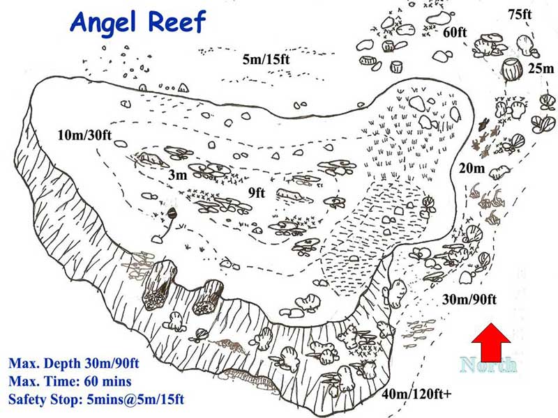
For example maps/images like this;
http://www.michaelmcfadyenscuba.info/im ... ef-map.jpg
What the map depends, I think you misunderstand me;
I would like to have an option to add underwater maps (situation maps).
For example maps/images like this;
http://www.michaelmcfadyenscuba.info/im ... ef-map.jpg
-
nick
- Site Admin
- Posts: 4363
- Joined: Sat Apr 12, 2008 8:33 am
- Dive Computer: Shearwater Teric
- Contact:
Re: Dive site map
Right now, you can add photos to dives. Those photos are visible as "Photos Taken Here" at each dive site. So, as a workaround, you can add the map to one dive that you've made at the site and it will be available.
I will log a feature request for more site specific photos.
Edit: Also, and this goes for everyone, have a browse through the User Guide. There's a ton of features hiding away, and not just related to sites. From sharing critters/sites to tricks like copy/paste of images to all sorts of other stuff.

Dive site map
Yes..There is a way to use your own maps for the background..Now i did it but it was very tedious thing. What i did match up the online web map with what the storm predator window was showing and then i over rode the old map for that location with the new one..If that makes sense..